
February 2010
LINCOLN, NE
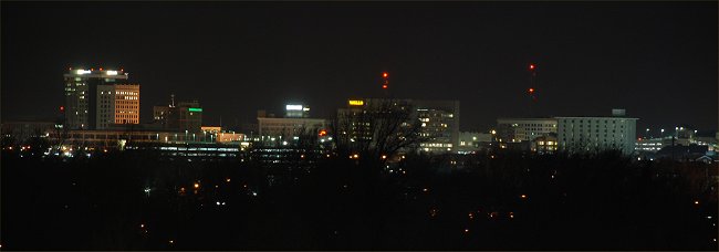
Photo
© K. Dewey, Applied Climate Science,
School of Natural Resources, University of Nebraska, Lincoln.
A night time view of the Lincoln, NE city
Center from Hardin Hall, home of this Web Site
Also see our
entire photo gallery
Also see our January 2010 Photo Gallery and our February 2010 photo gallery
LINK:
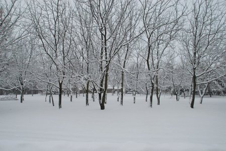
February 5, 2010: Snowy mid-winter day near Lincoln, NE
Lincoln Live Weather Watching Web Cams
NEW: Satellite Image Showing Snow Cover in our Area
NEW: It has only hit 40 F or higher once since December 1----How Rare is this?
NEW: January 2010: Global Temperatures 4th Warmest on record
NEW: January 2010 Statewide Temperature Rankings
NEW: Its Called "Global warming", not "Nebraska Warming" Year 2009 Review
NEW: It has only hit 50 F or higher once since December 1----How Rare is this?
NEW: January 2010 Temperature Graph
NEW: Year 2009 Global Temperatures 5th Warmest on Record
NEW: January 9, 2010: All Lower 48 states have subfreezing temperatures
NEW: Satellite Images Showing Snow Cover on January 9, 2010
Last month's Data: (January 2010)
|
Central Plains Severe Weather
Symposium and Family Weatherfest. 10th Anniversary!! Saturday, March 27, 2010
Event Website: Click Here |
 |
Monthly Snowfall 2009-2010
| . | . | |||||||
Nebraska Winter Weather Forecast Page
Lincoln, Nebraska Number of Days with High Temperatures 50o F or Higher,
Winter Seasons 1887-88 through 2009-2010
Note: Winter is defined as December 1-February 28 (29)
|
|
|||||||||||||||||||||||||||||||||||||||||||||||||||||||||||||||||||||||||||||||||||||||||||||||||||||||||||||||||||||||||||||||||||||||||||||||||||||||||||
| Winters with least number of days 50o F or Higher |
Winters with most number of days 50o F or Higher |
More information at this link: http://www.lincolnweather.org/lincoln-winter-50s.html
All data on this page are from the National Weather Service and HPRCC data archives.
NOTE: February 2010 was the 29th coldest out of 124 years of data (1887 - 2010)
| February, Lincoln, NE Rank Value Ending Date 1 8.2 2/28/1936 2 13.0 2/28/1979 3 13.1 2/28/1978 4 14.1 2/28/1899 5 16.1 2/28/1905 6 16.3 2/28/1989 7 18.9 2/28/1887 8 19.1 2/28/1900 9 19.2 2/28/1929 10 20.1 2/28/1975 11 20.5 2/28/1891 12 20.6 2/28/1960, 2/28/1949, 2/28/1993 15 21.2 2/28/1903, 2/28/2001, 2/28/1904 18 21.7 2/28/1894 19 21.8 2/28/1994 20 22.0 2/28/1893 21 22.1 2/28/1980 22 22.2 2/28/1895 23 22.4 2/28/1914, 2/28/1939 25 22.5 2/28/1985, 2/28/1902, 2/28/1889, 2/28/1965 29 22.6 2/28/2010, 2/28/1955 |
Note: all low temperatures of 0o F or lower are in BLUE.
| February | PREC |
MAX |
MIN |
MAX |
MIN |
Mean |
|||||||||
| Feb. 1 | 30 | 19 | 25 | +1 | 0.02 | 40 | 0.2 | ||||||||
| Feb. 2 | 29 | 12 | 21 | -3 | 0.00 | 44 | |||||||||
| Feb. 3 | 42 | 11 | 27 | +2 | 0.00 | 38 | |||||||||
| Feb. 4 | 36 | 30 | 33 | +8 | 0.42 | 32 | 1.0 | ||||||||
| Feb. 5 | 31 | 29 | 30 | +5 | 0.19 | 35 | 2.0 | ||||||||
| Feb. 6 | 35 | 26 | 31 | +5 | 0.05 | 34 | 0.5 | ||||||||
| Feb. 7 | 34 | 29 | 32 | +6 | 0.10 | 33 | 1.5 | ||||||||
| Feb. 8 | 33 | 5 | 19 | -7 | T | 46 | T | ||||||||
| Feb. 9 | 23 | 1 | 12 | -14 | 0.01 | 53 | 0.2 | ||||||||
| Feb. 10 | 23 | -2 | 11 | -16 | 0.00 | 54 | |||||||||
| Feb. 11 | 33 | 19 | 26 | -1 | 0.00 | 39 | |||||||||
| Feb. 12 | 31 | 17 | 24 | -3 | 0.00 | 41 | |||||||||
| Feb. 13 | 33 | 22 | 28 | 0 | 0.00 | 37 | |||||||||
| Feb. 14 | 22 | 13 | 18 | -10 | 0.04 | 47 | 0.8 | ||||||||
| Feb. 15 | 22 | 14 | 18 | -10 | T | 47 | T | ||||||||
| Feb. 16 | 28 | 16 | 22 | -7 | T | 43 | T | ||||||||
| Feb. 17 | 36 | 6 | 21 | -8 | 0.00 | 44 | |||||||||
| Feb. 18 | 38 | 13 | 26 | -3 | 0.00 | 39 | |||||||||
| Feb. 19 | 27 | 23 | 25 | -5 | 0.09 | 40 | 0.5 | ||||||||
| Feb. 20 | 29 | 23 | 26 | -4 | 0.02 | 39 | 0.1 | ||||||||
| Feb. 21 | 29 | 20 | 25 | -5 | 0.05 | 40 | 0.6 | ||||||||
| Feb. 22 | 26 | 9 | 18 | -13 | 0.00 | 47 | |||||||||
| Feb. 23 | 25 | 8 | 17 | -14 | 0.00 | 48 | |||||||||
| Feb. 24 | 22 | -1 | 11 | -20 | 0.00 | 54 | |||||||||
| Feb. 25 | 28 | 7 | 18 | -14 | 0.00 | 47 | |||||||||
| Feb. 26 | 36 | 13 | 25 | -7 | 0.00 | 40 | |||||||||
| Feb. 27 | 34 | 18 | 26 | -7 | 0.00 | 39 | |||||||||
| Feb. 28 | 33 | 15 | 24 | -9 | 0.00 | 41 | |||||||||
2010 |
PREC |
MAX |
MIN |
MAX |
MIN |
Mean |
|||||||||
| 0.99 | 1181 | 7.4 | |||||||||||||
|
DEPARTURE
|
-9.0 | -2.4 | -5.7 | +0.33 | -138 | +1.7 |
Warmest recorded FEBRUARY temperature, Leap Years: 83 F, February 29, 1972. Non-Leap Years: 79 F, Feb. 26, 1896 and Feb. 28, 1972.
Coldest recorded FEBRUARY temperature, -26 F, Feb. 11, 1899
& Feb. 13, 1905.
AVERAGE AND
TOTAL are FEBRUARY 2010. |
|
School of Natural Resources  |