
January 2008
Lincoln,
Nebraska Daily Climate Data
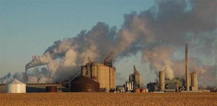
Jan. 2, 2008: Steam from this plant in northeast Lincoln roars into the -1 F frigid Winter air. ©Ken Dewey, UNL, SNR.
NEW: Lincoln Live Weather Watching Web Cams
|
Saturday, March 29, 2008. Central Plains Severe Weather Symposium and family Weatherfest. Event Website: Click Here |
 |
Lincoln, NE, Monthly Snowfall 2007-08
PREC |
MAX |
MIN |
MAX |
MIN |
Mean |
|||||||||
| 7 | 15 | -8 | 0.00 | |||||||||||
| 23 | -1 | 11 | -12 | 0.00 | 54 | |||||||||
| 37 | 14 | 26 | +4 | 0.00 | 39 | |||||||||
| 37 | 25 | 31 | +9 | 0.00 | 34 | |||||||||
| 44 | 20 | 32 | +10 | 0.00 | 33 | |||||||||
| 47 | 28 | 38 | +16 | 0.00 | 27 | |||||||||
| 44 | 28 | 36 | +14 | 0.09 | 29 | |||||||||
| 40 | 25 | 33 | +11 | 0.00 | 32 | |||||||||
| 41 | 23 | 32 | +10 | 0.00 | 33 | |||||||||
| 37 | 23 | 30 | +8 | 0.02 | 35 | 0.3 | ||||||||
| 39 | 17 | 28 | +8 | 0.00 | 37 | |||||||||
| 32 | 25 | 29 | +7 | 0.00 | 36 | |||||||||
| 39 | 17 | 28 | +6 | 0.00 | 37 | |||||||||
| 26 | 11 | 19 | -3 | 0.00 | 46 | |||||||||
| 39 | 13 | 26 | +4 | 0.00 | 39 | |||||||||
| 32 | 16 | 24 | +2 | 0.21 | 41 | 3.0 | ||||||||
| 17 | 9 | 13 | -9 | 0.05 | 52 | 0.5 | ||||||||
| 25 | -1 | 12 | -10 | 0.02 | 53 | 0.3 | ||||||||
| 13 | -9 | 2 | -20 | T | 63 | T | ||||||||
| 19 | -1 | 9 | -13 | 0.00 | 56 | |||||||||
| 19 | 8 | 14 | -8 | 0.01 | 51 | 0.1 | ||||||||
| 20 | -1 | 10 | -12 | 0.00 | 55 | |||||||||
| 30 | -3 | 14 | -8 | 0.02 | 51 | 0.5 | ||||||||
| 19 | -10 | 5 | -18 | 0.00 | 60 | |||||||||
| 36 | 15 | 26 | +3 | T | 39 | T | ||||||||
| 45 | 14 | 30 | +7 | 0.00 | 35 | |||||||||
| 54 | 21 | 38 | +15 | 0.00 | 27 | |||||||||
| 60 | 32 | 46 | +23 | T | 19 | |||||||||
| 39 | 5 | 22 | -1 | 0.02 | 43 | 0.2 | ||||||||
| 19 | 4 | 12 | -12 | 0.00 | 53 | |||||||||
| 21 | 9 | 15 | -9 | 0.00 | 50 | |||||||||
| 383 | 1309 | 4.9 | ||||||||||||
| 32.8 | 12.4 | 22.6 | ||||||||||||
|
DEPARTURE
|
-0.4 | +0.9 | +0.2 | -0.23 | -19 | -0.2 |
Warmest recorded JANUARY temperature, 73 F, January 10, 1990. Coldest recorded JANUARY temperature, -33 F, January 12, 1974 Most JANUARY Snowfall: 23.0 inches, 1915. Least January Snowfall: Trace (flurries and not measurable), 3 of the last 107 years (1900, 1986, 2006). AVERAGE AND TOTAL are JANUARY 2008. NORMAL is the 1971-2000 Standard Normals. DEPARTURE is JANUARY 2008. Average measured against 1971-2000 normals. MAX = Observed Maximum and MIN = Observed Minimum temperatures in deg. F.. MEAN = Observed Mean Daily temperature in deg. F.. DEP = Departure from normal ( __ = below normal, + above normal) in deg. F.. PCPN = Observed daily precipitation (midnight to midnight, CST), in inches. REC PREC = Record daily precipitation amount in inches. REC MAX = Record Maximum temperature in deg. F. REC MIN = Record Minimum temperature in deg. F.. HDD = heating degree day units (base of 65 degrees). CDD = cooling degree day units (base of 65 degrees). AVG MAX = Daily Normal High Temperature (1971-2000 normals). AVG MIN = Daily Normal Low Temperature (1971-2000 normals). AVG MEAN = Daily Normal Mean Temperature (1971-2000 normals). SNOW = Snowfall in inches. |