
 |
 |
Last month's Data: (November 2009)
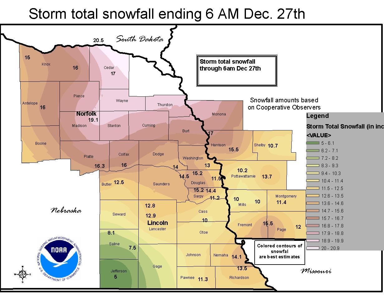
December 24-27, 2009 Snowfall Map for Eastern Nebraska
NEW WEBSITE: Lincoln's Cold Wave Climatology
NEW WEBSITE: Storm Horizons (Severe Weather Climatology)
NEW WEBSITE: One Day and Two-Day Snowfall Records For Lincoln, NE
Climate News:
|
Central Plains Severe Weather
Symposium and Family Weatherfest 10th Anniversary! Saturday, March 27, 2009
|
 |
Year 2009 Precipitation (in inches)
Compared to Normal (RED is above normal and
BLUE is below normal)
JAN
FEB
MAR
APR
MAY
JUN
JUL
AUG
SEP
OCT
NOV
DEC
TOTAL
2009
0.38
0.64
0.18
1.52
1.17
6.18
1.84
3.20
1.25
4.24
0.10
2.42
23.08
NORMAL
0.67
0.66
2.21
2.90
4.23
3.51
3.54
3.35
2.92
1.94
1.58
0.86
28.37
Nebraska Winter Weather Forecast Page
New daily precipitation record: December 8, 2009: 0.72 inches. Old record: 0.37 inches set in 1919.
New daily precipitation record: December 25, 2009: 0.62 inches. Old record: 0.42 inches set in 1892.
New December snowfall record of 24.3 inches. Old record was 22.3 inches set in 1945 (monthly records start in 1899)
The December 2009 total of 24.3 inches is within 2 inches of the most snowfall for any month since records began in 1899.
| The December 25, 2009 snowfall of 9.5 inches
was the 6th greatest one-day snowfall ever recorded for Lincoln. The 11.2 inches that fell December 24-25 is the 8th greatest 2-day snowfall total for Lincoln. One Day and Two-Day Snowfall Records For Lincoln, NE |
Precipitation measurement units are "inches"
DECEMBERYEAR |
AMOUNT | RANK |
YEAR |
AMOUNT | RANK |
| DECEMBER Average Temperatures | |||||||||||||||||||||||||||||||||||||||||||||||||||||||||||||||||||||||||||||||
|
|||||||||||||||||||||||||||||||||||||||||||||||||||||||||||||||||||||||||||||||
All temperatures 0oF or lower are noted in BLUE
| December | PREC |
MAX |
MIN |
MAX |
MIN |
MEAN |
|||||||||
| December 1 | 59 | 33 | 46 | +15 | 0.00 | 19 | |||||||||
| December 2 | 38 | 21 | 30 | -1 | 0.00 | 35 | |||||||||
| December 3 | 26 | 14 | 20 | -10 | T | 45 | T | ||||||||
| December 4 | 30 | 11 | 21 | -9 | 0.00 | 44 | |||||||||
| December 5 | 44 | 13 | 29 | -1 | 0.00 | 36 | |||||||||
| December 6 | 27 | 17 | 22 | -7 | 0.19 | 43 | 2.9 | ||||||||
| December 7 | 18 | 2 | 10 | -19 | 0.08 | 55 | 1.1 | ||||||||
| December 8 | 23 | 14 | 19 | -10 | 0.72 | 46 | 6.9 | ||||||||
| December 9 | 14 | -3 | 6 | -22 | 0.02 | 59 | 0.2 | ||||||||
| December 10 | 19 | -13 | 3 | -25 | 0.00 | 62 | |||||||||
| December 11 | 24 | -7 | 9 | -19 | 0.00 |  |
56 | ||||||||
| December 12 | 32 | -1 | 16 | -11 | 0.00 | 49 | |||||||||
| December 13 | 27 | 9 | 18 | -9 | T | 47 | |||||||||
| December 14 | 19 | 2 | 11 | -16 | 0.02 | 54 | 0.2 | ||||||||
| December 15 | 10 | -7 | 2 | -25 | 0.00 | 63 | |||||||||
| December 16 | 29 | 2 | 16 | -10 | 0.00 | 49 | |||||||||
| December 17 | 31 | 11 | 21 | -5 | 0.00 | 44 | |||||||||
| December 18 | 37 | 22 | 30 | +4 | T | 35 | |||||||||
| December 19 | 29 | 23 | 26 | +1 | 0.00 | 39 | |||||||||
| December 20 | 38 | 24 | 31 | +6 | 0.00 | 34 | |||||||||
| December 21 | 37 | 21 | 29 | +4 | 0.00 | 36 | |||||||||
| December 22 | 31 | 20 | 26 | +1 | 0.00 | 39 | |||||||||
| December 23 | 33 | 31 | 32 | +8 | 0.45 | 33 | T | ||||||||
| December 24 | 32 | 11 | 22 | -2 | 0.20 | 43 | 1.7 | ||||||||
| December 25 | 21 | 7 | 14 | -10 | 0.62 | 51 | 9.5 | ||||||||
| December 26 | 25 | 21 | 23 | -1 | 0.10 | 42 | 1.6 | ||||||||
| December 27 | 31 | 20 | 26 | +2 | T | 39 | T | ||||||||
| December 28 | 30 | 5 | 18 | -5 | 0.00 | 47 | |||||||||
| December 29 | 22 | -1 | 11 | -12 | T | 54 | |||||||||
| December 30 | 34 | 10 | 22 | -1 | 0.02 | 43 | 0.2 | ||||||||
| December 31 | 17 | 1 | 9 | -14 | 0.00 | 56 | |||||||||
| December | PREC |
MAX |
MIN |
MAX |
MIN |
MEAN |
|||||||||
| 2.42 | 1397 | 24.3 | |||||||||||||
| -8.2 | -5.5 | -6.8 | +1.58 | +209 | +18.9 |
All of the data on this page are from the official NWS data archives for Lincoln, NE
Additional data for Lincoln, NE can be found at the HPRCC web site.
Warmest recorded December temperature, 75 F, December 6, 1939. Coldest recorded December temperature, -27 F, December 22, 1983. Most December Snowfall: 22.3 inches, 1945. Least December Snowfall: 0.0 inches, 3 of the last 110 years (2004, 1991 & 1928) AVERAGE AND
TOTAL are DECEMBER 2009. |
|
School of Natural Resources  |